What we do
Building Peace
Protection of Water During & After Armed Conflict
Shaping Law and Policy
Education and Training
Setting the Research Agenda
Consultancy Services
Who we are
Vision and Mission
Governance
Our Team
Partners
Resources
Events
News
Contact us
Resources
The Geneva Water Hub’s online platform offers a wide range of resources. You will find a range of different formats each created especially for a particular target audience – student, scientist or professional.
Filter by
Thematics
Building Peace
Protection of Water During and After Armed Conflict
Shaping Law and Policy
Education and Training
Setting the Research Agenda
Consultancy Services
Support type
Brief and commentary
Course
Multimedia
Report
Science publication
03.04.2025
Setting the Research Agenda
Brief and commentary
Bridging Gaps in Water Governance: Addressing Conflict and Climate Challenges
A PRIO Policy Brief by Stefan Döring examining the intersection of water governance, armed conflict, and climate-related stress.
Read more
13.03.2025
Setting the Research Agenda
Report
Outputs from the SPI 2024 Edition
The first edition of our SPI Grant for Water Diplomacy was launched on June 27th 2024. The event showcased the successful projects, discussed approaches to science-policy...
Read more
10.03.2025
Setting the Research Agenda
Brief and commentary
Left, right and centre – Policy note n°4 – Water mediation
The fourth article in our series “Left, Right and Centre” analyses how technocratic solutions to complex water issues often ignore social-ecological tradeoffs and governa...
Read more
10.03.2025
Setting the Research Agenda
Brief and commentary
Left, right and centre – Policy note n°3 – Knowledge co-production, ecosystem se...
The third article in our series “Left, Right and Centre” analyses recent developments in the highlands region of Cayambe in northern Ecuador, where the Confederation of ...
Read more
01.10.2024
Protection of Water During and After Armed Conflict
Report
Research Paper "Vortex of Pain: Human Rights Implications of the Gaza Armed Conf...
Read more
29.05.2024
Setting the Research Agenda
Brief and commentary
Geneva Water Hub at the Bandung Summit: Key Highlights and Call to Action
We are pleased to report the success of the Bandung Spirit Water Summit during the World Water Forum in Bali in May 2024. The Water and Peace session was particularly imp...
Read more
22.05.2024
Protection of Water During and After Armed Conflict
Report
Report - Global Alliance to Spare Water from Armed Conflicts
On 22-23 Nov 2023, the Geneva Water Hub and Slovenia’s Ministry of Foreign Affairs hosted a workshop for a Global Alliance to Spare Water from Armed Conflicts. This repor...
Read more
06.05.2024
Protection of Water During and After Armed Conflict
Multimedia
‘The Weaponizing of Water in Contemporary Armed Conflicts’ : Mark Zeitoun interv...
Prof. Mark Zeitoun, joins other distinguished experts in the latest episode of the Geneva Academy's podcast, "In and Around War(s)". Together, they delve into the crucial...
Read more
03.05.2024
Building Peace
Multimedia
IC Forum Switzerland 2024: Thematic Session #4 - Water and Peace
Dr. Danilo Türk, Geneva Water Hub's Lead Political Advisor, has been invited to participate in the 2024 International Cooperation Forum Switzerland held in April in Basel...
Read more
02.05.2024
Protection of Water During and After Armed Conflict
Report
Highlighting Expert Contributions in International Law and the Protection of Fre...
We are pleased to recognize the efforts of our colleagues from the Geneva Water Hub, Mara Tignino and Tadesse Kebebew, whose expertise in international humanitarian law a...
Read more
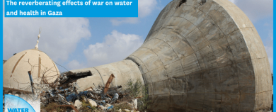
17.04.2024
Protection of Water During and After Armed Conflict
Report
"Fully foreseeable: The reverberating effects of water and health in Gaza"
The Geneva Water Hub's study on Gaza exposes severe health crises resulting from damaged water and sewage services. The region faces dire consequences such as dehydration...
Read more
05.02.2024
Setting the Research Agenda
Multimedia
Science Policy Incubator Grant on Water Diplomacy
The objective of this grant is to give policy-oriented scholars of water diplomacy and hydropolitics an opportunity to bridge their research to policy. This might involve...
Read more
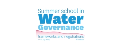
29.01.2024
Education and Training
Course
Summer School in Water Governance: Frameworks and Negotiations - July 1-12 2024
The Geneva Water Hub is leading the organisation of the University of Geneva Summer School in Water Governance. If you are a professional acting at strategic le...
Read more
28.11.2023
Setting the Research Agenda
Brief and commentary
Left, right and centre – Policy note n°2 – Water for peace, what contributions t...
Across the global water community, thought leaders, non-governmental and inter-governmental organizations, academia and communities of practice are increasingly "position...
Read more
17.10.2023
Education and Training
Course
MOOC n°4 - Water Cooperation and Diplomacy
It's a great pleasure to launch this MOOC on Water Cooperation and Diplomacy! This on line training includes newly developed as well as innovative material and data addre...
Read more
Pagination
Page
1
Page
2
Page
3
Page
4
Page
5
…
Next page
Next ›
Last page
Last »